On Thursday 28th of March, Guilherme A. Pedrão will give a talk at 1 pm, on the 2nd floor of the 504 building:
Guilherme is in PhD, working with Stephanie Duchamp.
Title: Brazil current system dynamics in the Southwestern Atlantic over the past ~800 ka: Inputs from paleoproductivity data
This seminar aims to present you a few of my Ph.D. works, which aim to unveil the dynamics of the main water masses in the Brazil Current (BC) and Brazil Coastal Current (BCC) system and their impact on paleoproductivity over the past 800 ka. In the Southwestern Atlantic, the water masses that are the main conduits for nutrient supply to the photic zone are the Coastal Water (CW) and the South Atlantic Central Water (SACW). The BCC predominantly transports nutrients from the CW to the open ocean through horizontal movements. On its surface, The BC is characterized by the transport of the oligotrophic Tropical Water (TW). Conversely, the SACW represents an eutrophic deeper water mass that hits the photic zone by coastal upwelling in the Cabo Frio region (north of our study area) under favorable wind conditions (northeast winds).
In this context, the cores were retrieved from different environments, ranging from shallow water depths (GL-824 at 532m and GL-1109 at 848m) to relatively deep water depths (GL-854 at 2220 m) that span the Last Glacial Maximum (LGM), as seen in cores GL-824 and GL- 1109, and the last 770 ka, as observed in core GL-854. Assessments were based on micropaleontological (coccoliths and foraminifera) and geochemical analyses (bulk rock major elements and residual Sr/Ca signal on coccoliths).
We demonstrated that since the LGM, paleoproductivity changes (coccolith abundances) at the shallower sites are paced by sea-level oscillations that control the position of the main flow of BC. During low sea-level periods, i.e., mainly during the LGM (high Fe/Ca and Ti/Ca), the offshore displacement of the BC is associated with the occurrence of mesotrophic CW that generates higher productivity at the studied site. In contrast, during periods of high sea level, i.e., from the Late to Early Holocene (low Fe/Ca and Ti/Ca), the BC transported warm and oligotrophic tropical waters to the core sites, preventing any nutrient inputs from deeper layers or coastal waters.
Productivity at core GL-854 site reaches maximum values during glacial Terminations. The occurrence of large coccolithophore morphotypes, such as Helicosphaera spp., Calcidiscus spp., and Coccolithus pelagicus, together with peaks of residual Sr/Ca signal testify for enhanced nutrient supply together with increased coccolithophores productivity rates. In parallel, an increase in the abundance of Florisphaera profunda and the difference among foraminifera estimated Sea Surface Temperatures (10m and 100m) testifies for an enhanced stratification and, therefore, a stronger influence of the SACW. Indeed, during the Terminations, variations in the atmospheric semipermanent pressure high in the Atlantic Ocean (South Atlantic High) might have increased the prevalence of northeast winds that permitted a more frequent and extensive influence of SACW coastal upwelling off Cabo Frio and, hence, its impact on open ocean nutrient concentrations.
Such results show that paleoproductivity patterns significantly differed from site to site, depending on the studied time interval and primary nutrient source. They represent the starting point of my postdoc research work, funded by a CAPES-COFECUB partnership based at GEOPS and the IFREMER (Brest). The aim is to better understand the dynamics of both, the North Brazil Current and the Brazil Current based on paleoproductivity proxies (organic markers and coccolith assemblages) over the past 300 ka (including the last interglacial) and try to unravel their impact on the marine carbon cycle.
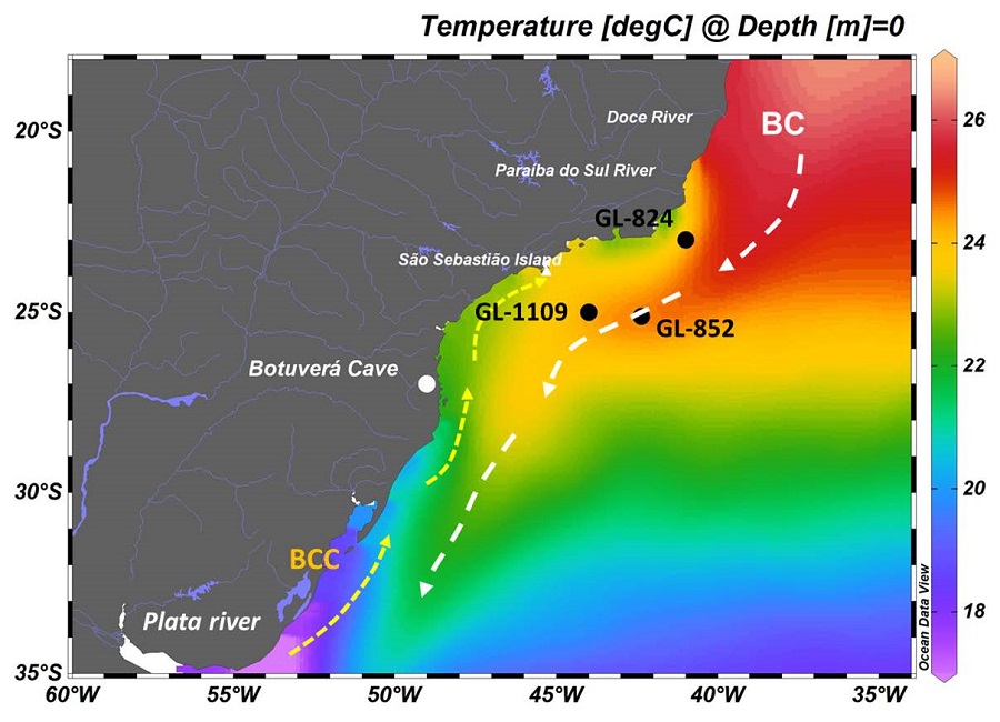
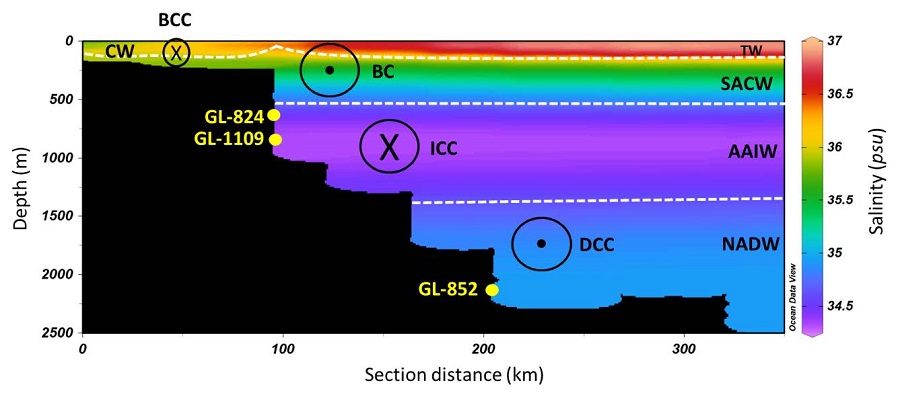
Figure 1—Location of the cores with the main currents and water masses. (a) The arrows represent the main flows of the Brazil Current (white) and the Brazil Coastal Current (Yellow). The black dots represent the cores’ locations.(b) Vertical distribution of the water masses. The dashed lines represent the limits between the water masses, while the black circles indicate the direction of the currents that transport them.